



Key Takeaways
- ISRO Satellites tracked Cyclone Dana, providing constant inputs on its status.
- The cyclone is expected to weaken further into a Cyclonic storm and then into a Deep Depression, Depression, and a Low Pressure.
- ISRO’s Polar orbiting satellite EOS-06 and the geostationary satellite INSAT-3DR provided valuable information on the cyclone status.
Chennai: The Satellites launched by the Indian Space Research Organisation (ISRO) has tracked the Cyclone Dana, that crossed the North Odisha coast early on Friday morning, by providing constant inputs on its status. that helped in better monitoring and mitigating the cyclone threat.
It crossed the North Odisha coast close to Habalikhati Nature Camp (Bhitarkanika) and Dhamara between 0130 hrs and 0330 hrs today, as a severe cyclonic storm with a wind speed of 100-110 kmph and gusting to 120 kmph and lay centered over Odisha coast, about 60 km northeast of Paradip (Odisha), 20 km southeast of Dhamara (Odisha)
and 150 km southwest of Sagar Island (West Bengal).
The system is expected to weaken further into a Cyclonic storm and then into a Deep Depression, Depression and a Low Pressure.
ISRO in an update said its satellites are tracking the cyclone since October 20.
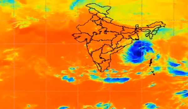
ISRO’s Polar orbiting satellite EOS-06 and the geostationary satellite INSAT-3DR are regularly providing valuable information on the cyclone status.

ISRO polar orbiting satellite EOS-06 Scatterometer sensor provided the status of ocean winds and their circulation well before the formation of the cyclone.
The Space Agency also shared images of the EOS-06 satellite Scatterometer winds image showing the genesis of Cyclonic Storm ‘DANA’ in Bay of Bengal on October 20, much ahead of its intensification in to Deep Depression and Cyclonic Storm, besides showing the ocean wind intensity and direction during October 19 to 23.
Further, ISRO’s geostationary satellite INSAT-3DR provided the synoptic dynamics of the clouds at regular intervals.
These satellite inputs helped in better monitoring and mitigation of the cyclone threat
to India, it said.